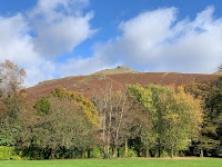
A short 6km walk on a fine Autumn day but both plagued by lingering colds.
Route: Free car parking spaces all being full, leaving the car in the Broadgate Meadow car park (now pay and display, again, and £3 for 2 hours) and walking to and past the Swan Hotel and 100m up the quiet road before turning left at the end to find a tarmac drive signposted 'Allcock Tarn' rising beside a stream. At the end, bearing left to rise on a paved stone 'staircase' as far as a locked gate into a wood and then, instead, bearing right across the fell, with much evidence of recent elegant Fix the Fells paving work, to reach the ridge and then up that to Stone Arthur. Descending steep and pathless north-west down a grassy slope towards Tongue Gill to pick up the path down from Grizedale Hause and along above the valley before turning right through a boggy field to Winterseeds and then left along the main road back to the start.
Conditions: sunny but cool in the wind.
Pub: Tweedies, Grasmere for Fyne ** and lunch.
27 October 2019
26 October 2019
Lorton to Braithwaite traverse via Lord’s Seat
A 15km linear walk to get the Middle Ruddings Beer Festival (both battling colds).
Route: leaving the village to the south, climbing to cross Whinlatter Pass and thence over High How to the easterly path, rather prickly with gorse in places. Entering the forest at a stile and continuing along an ancient-feeling forest track, overgrown in parts, following it right and downhill to cross the stream and rise to a T-junction. Turning left on a forest road, ignoring a left-hand tun onto a bridleway but following along Aiken Beck, crossing it at a bridge and then when the track bends right, taking a smaller path straight on gaining altitude to reach a made path and follow it left to Lord’s Seat. Retracing the route and taking a marshy path to the more northerly ‘Mound’ on Ullister Hill, then on and down and up to Seat How. Continuing straight ahead on a path marked on the map but with very little evidence on the ground. Turning right onto the lower of two forestry tracks but finding the Two Gills path downhill, crossing another track to reach Comb Beck and following it to Thornthwaite. Turning right on a track heading south through woods then bearing south-east on an enclosed path along the edge of a field before turning left to cross a field to Lanefoot Farm and then right along the top road to the rear entrance of Middle Ruddings for a beer. Afterwards, walking to the 4:37pm bus in Braithwaite.
Conditions: mainly completely still, with cloud above the tops and occasional spits of rain but clearing to some sun.
Pub: Middle Ruddings for Dudda’s Tun Original Cider and Garden Cider Raspberry and Rhubarb.
20 October 2019
Kentmere Pike via Wrengill Quarry
Route: leaving the car just short of Hallow Bank, Kentmere, on High Lane just before the bridleway to Sadgill and taking that bridleway over to Long Sleddale and then the long, stony road up to the head of the valley. After a signpost in an enclosed area, taking a gate to the left and then a faint path to the River Sprint and into quarry workings, always keeping to the right. After passing a waterfall, looking for a way to ford the stream but being forced to continue past another fence crossing the way and another 200m before it was possible to do so (the gill being high). Then backtracking, climbing the (previously encountered) fence at a fence-wall join (alongside which a direct route goes to the summit) and moving pathless and across marshy ground to reach the Steel Rigg-Raven Crag ridge with views down the valley. Staying to the right hand/north side of a marshy comb to make a beeline steeply uphill to the summit of Kentmere Pike. Descending the summit ridge taking the first, fine diagonal short-cut with wide-open views to the right to reach Hallow Bank and thence back along the road, 400m, to the car.
Conditions: sunny though with a bitter wind, giving way to cloud with a threat of rain from the north.
Pub: the Eagle and Child, Staveley, for Jennings Sneck Lifter and a bowl of nachos and cheese.
13 October 2019
The Helm
A short 6km walk on a wet Sunday evening (5pm) after all else had failed.
Route: leaving the house and heading uphill through the station, past the Station Inn and along the road behind/to the east of the Helm to the start of a footpath round the south end. Here, for the first time, taking a path through bracken on the Friends of the Lake District-owned side, up the end of the Helm (perhaps 30m to the east of the familiar path), but kept away from a direct route to the summit by a small cliff. On reaching a fence, climbing to the ridge and then back to the summit. Then along the ridge, on the east side, descending to the Station Inn and then home.
Conditions: low cloud and constant drizzle.
Pub: the Station Inn, Oxenholme, for Moorhouse Blonde Witch and Settle Brewery Blonde.
6 October 2019
Yew Crag
A short 5km circuit on a wet low cloud day.
Route: from the lower NT car park for Aira Force taking the path eastwards just under Green Fell though spurning the higher level fork left for rather an awkward muddy and stony path through trees down towards the road but staying just inside the fall as war as a stile back from the road on the right. Turning left and climbing on a zig-zagging path (looking like a Victorian path to a viewpoint), slipping through a gap created by a rock flake up rock steps, and then keeping right on a path. Crossing a faint traversing path and continuing to the cliff. Where a rock overhangs, ignoring the older way bearing right. Instead, keeping left and clambering up a shallow gully lined with tree roots. At the top bearing left and right on a faint path leading past a rocky crest to a stile in the cliff-bounding fence. Turning left on the Watermillock path to descend to meet the outward path but bending right up hill to look at the falls (in superlative form) before returning to the car park.
Conditons: low clouds and intermittent rain.
Pub: the Watermill, Ings, for Watermill Ruby, Ruby, Ruby, Ruby and Ruff Justice.
5 October 2019
Workington to Seaton circular saunter
A 10km stroll on a cycle track and riverside footpaths.
Route: Leaving the car at Workington station (free parking) and heading east round by the stream on quiet streets to the edge of the commercial area to pick up Sustrans Route 71 crossing the river on a foot/cycle bridge (2011). Carrying on on an ex-railway line through woods, bending right to avoid Route 72, through Seaton, until the path was parallel to Camberton Road. Here climbing steps on the left then to cross over the path on a new wooden footbridge, cross the road, with views of the fells, and descend a narrow muddy track to the high bank of the river. Here negotiating a very wet and muddy field corner on planks and then continuing on drier ground to reach Seaton Mill and its long weir (complete with heron) just before Barepot. Continuing towards Workington, under the A596, to reach the outward cycle bridge and heading to Carnegie Theatre and Arts Centre for the Workington Beer Festival. Thence back to the start.
Conditions: cloudy but not cold.
Pub: The Workington Rotary Oktoberfest Beer Festival at the Carnegie Theatre for Ennerdale Bridge The Harbour Master and Westgate Atlantic Hop.
Subscribe to:
Posts (Atom)