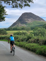
An 8km practice climb with Christine in advance of her sunrise ascent of Helvellyn.
Route: leaving the cars at the forestry car park by Wythburn Church (£7 in coins for the day x 2 for 2 cars, luckily achieved with 7p to spare) and ascending the steep often stepped path up overlooking Comb Gill and then turning right, south to ascend the lip of the comb and then up Birk Side on an alluvial subsoil path in large zigzags to the summit plateau, cutting pathless to find a strikingly situated summit cairn. Descending the same way having first approached what may have been a slightly higher cairn, making cautious progress down the stone steps.
Conditions: despite a forecast for cloud, a largely sunny day.
Pub: The Kings Head, Thirlspot for Charles Wells Bombardier.
31 August 2020
30 August 2020
Lorton to Braithwaite over the Lord's Seat fells
A 13km run from the cottage to Middle Ruddings to say goodbye to Andy, Liz and Tom on their penultimate day at the helm (sniff).
Route: from the cottage taking the steep cyclists' route to the start of Whinlatter and crossing to take the rough path zig-zagging up and then contouring round below High How. Turning up right to gain the How and then bearing left to leave the field in the corner and then contouring west and then north on the fairly new track. After descending slightly, heading right up a grassy track to the southern outlier of Kirkfell and then following faint paths north to the summit and clearer ones east and then southeast (over a subsidiary summit) to reach Graystones. From here heading north to meet the fence and follow it down right to cross Widow Hause (the slopes below all clear-felled now) and on up to the summit of Broom Fell and on to Lord's Seat on clear paths, with occasional marshy bits, passing a steady stream of friendly walkers. From Lord's seat following the obvious path down southeast and, at the second clear turning, bearing left to join the 'North Loop' MTB route and run 1.5km down, bearing slowly round the east side of Seat How.
Due south of Seat How, turning down left on a wide grassy path through trees bending round the head of the Comb Beck ravine, and then turning left again to join the excellent reinforced Two Gills Path running steeply down the narrow wooded valley with the first gill/beck, crossing another wide forest track and dog-legging right-left across a forest road to continue down to follow Comb Beck down to Thornthwaite on wider paths.
Conditions: Surprisingly bright and sunny with excellent visibility most of the way after a week of terrible weather, clouding over for 3 hours of bus stop (in-)action
Pub: At Middle Ruddings, in two shifts (pre and post the non-arrival of a theoretical 1437 bus to Buttermere): Twisted Wheel Brew Co, Speed Wobble, Fell Brewery, Numbers Game, Full Circle Brew Co, Looper, Keswick Brewing Co, Time for a Pint and Brew York, Brownie Pints.
Route: from the cottage taking the steep cyclists' route to the start of Whinlatter and crossing to take the rough path zig-zagging up and then contouring round below High How. Turning up right to gain the How and then bearing left to leave the field in the corner and then contouring west and then north on the fairly new track. After descending slightly, heading right up a grassy track to the southern outlier of Kirkfell and then following faint paths north to the summit and clearer ones east and then southeast (over a subsidiary summit) to reach Graystones. From here heading north to meet the fence and follow it down right to cross Widow Hause (the slopes below all clear-felled now) and on up to the summit of Broom Fell and on to Lord's Seat on clear paths, with occasional marshy bits, passing a steady stream of friendly walkers. From Lord's seat following the obvious path down southeast and, at the second clear turning, bearing left to join the 'North Loop' MTB route and run 1.5km down, bearing slowly round the east side of Seat How.
Due south of Seat How, turning down left on a wide grassy path through trees bending round the head of the Comb Beck ravine, and then turning left again to join the excellent reinforced Two Gills Path running steeply down the narrow wooded valley with the first gill/beck, crossing another wide forest track and dog-legging right-left across a forest road to continue down to follow Comb Beck down to Thornthwaite on wider paths.
Reaching Thornthwaite and running down through the village to turn right in the centre on the track running south out of the village to come to a minor road. Crossing this to pick up the trail on a much smaller footpath, later on overhung by trees and fenced in to the left, exiting to the left over a stile to run down a field to Lane Foot Farm and turn right along a minor road to the back entrance to Middle Ruddings.
Conditions: Surprisingly bright and sunny with excellent visibility most of the way after a week of terrible weather, clouding over for 3 hours of bus stop (in-)action
Pub: At Middle Ruddings, in two shifts (pre and post the non-arrival of a theoretical 1437 bus to Buttermere): Twisted Wheel Brew Co, Speed Wobble, Fell Brewery, Numbers Game, Full Circle Brew Co, Looper, Keswick Brewing Co, Time for a Pint and Brew York, Brownie Pints.
29 August 2020
Papcastle nettly tootle
A theoretically interesting 7km run from the village of Papcastle but not to be repeated in nettle season.
Route: leaving the car parked beside the minor road that serves as a ‘slack run’ round the southern boundary of the village and taking the path towards the river, ignoring a sign saying that it had been 'eroded'. Running west along the river on grass, under the A591 and crossing what would have been an impassable building site (probably repairing flood damage) in working hours. Then negotiating a footbridge hidden by gorse to continue with views to the right of the disused railway. Crossing a bigger footbridge and turning right along a stream, slowing to walking pace to negotiate nettles and mud and eventually reaching Priests Bridge. Turning right along the road for 200m before turning right to cross fields on the route of a Roman road and getting a sudden fine view of the North Western fells. Sadly after this, being funnelled into nettled-filled flooded paths between fields and making very slow and painful progress to reach a c-road back into Papcastle and turning right downhill to return to the car.
Conditions: a dry cool evening with high clouds.
Pub: The Belle Vue, Papcastle, for uninspiring Jennings Cumberland Ale before picking up (delicious, by contrast) Fermento take-away pizzas.
22 August 2020
Bannerdale Crags
A 12km walk with Angie, Alistair and Christine (who was in training for a sunrise ascent of Helvellyn).
Route: leaving the car just south of the Mungrisdale village hall and walking along the road, over the river and along a muddy track north of River Glenderamackin. The path having previously been washed away, following a newly instated path on huge stone slabs across very marshy land to descend to cross a foot bridge. Sadly, here, with the riverside path still washed away, picking a damp route above the gorge of the river with a very damp descent to cross a swift flowing Bannerdale Beck and then ascend a clear path on a grassy ridge, gradually steepening to the main ridge with evidence of slate workings and onto the top of Bannerdale Crags. At the top, heading east round the comb to descend a clear gently sloping path back to the foot bridge and thence to the pub.
Conditions: periods of squally rain.
Pub: The Mill Inn, Mungrisdale, for Robinson’s Dizzy Blonde.
21 August 2020
Buttermere circuit
A late afternoon run in a pause in Storm Ellen’s rain, if not gusty wind.
Route: leaving the car at the NT car park (free to members and 2/3 full despite the very poor weather) and running past the Bridge Hotel to the lake and then via the reinstated footbridge to the path on the far, western, side of the lake. Along this to the head of the lake and then back first on the road and then on the newly re-engineered path on the eastern shore. Taking the higher path doubling back to cross over, rather than through, the tunnel. At the end of the lake turning left at a fork to keep along the northern lake shore and hence back on the outward route but sopping, for the first time, at the Buttermere Court Hotel (ex the Fish). Later, at a walk, back to the car.
Conditions: cloudy and windy but only some damp in the wind.
Pub: The Buttermere Court Hotel for Allendale Pale and Wagtail.
20 August 2020
Fellbarrow
A late afternoon/early evening stroll to redeem a lazy day.
Route: from the cottage to Low Lorton across fields via the church, across the river and rising past Low Bank Farm and High Bank on the green road rising onto the shoulder of the hill. Taking the unofficial but very well established track south, at first a little muddy and then grassy to reach open access land. Here failing to reunite a mother and offspring sheep dyad. Then, steeply uphill away from Rosemary and her brother (not Si, as we had thought), seen a bit too far behind to merit sociability, to reach Hatteringill Head and descending and ascending to reach Fellbarrow. Keeping to the (undulating) summit ridge to Smithy Fell, Sourfoot Fell and the valley-overlooking viewpoint below Watching Crag. Then descending, at a run, the zigzagging path to Thackthwaite and back along the road to Low Lorton, retracing the outward route.
Conditions: a warm stiff breeze probably heralding Storm Ellen forecast for the following day.
Pub? No but, back at the cottage, a bottle of Lidl’s Hatherwood Golden Goose, which wasn’t bad.
15 August 2020
Circuit of Hayeswater
An 18km walk with Paul Taylor on a glorious sunny day.
Route: finding the car park at Hartsop full by 10am, parking two cars in a layby just north of the Brotherswater Inn and backtracking to find the path below the level of the road and folllowing this to Hartsop. Then taking the higher of the two possible paths north and forking right, uphill, to reach Boredale Hause, here turning sharp right to approach Angletarn Pikes and climbing them by turning left along a grassy path to sneak up first to the northerly one and then the southerly one. Descending to the main path by the tarn (lots of swimmers!) and following this to Satura Crag keeping to the contouring path bypassing Rest Dodd and climbing to the Knott and along the Straits of Riggindale to High Street. Thence to Thornthwaite Beacon and a hot, scrambly, loose descent to Thresthwaite Mouth and re-ascent over Thresthwaite Crag to Stony Cove Pike and Caudale Moor. From the summit, descending the ridge steeply to the north-west overlooking Caudale quarry, following adits for much of the way and then bending right through the bracken to cross the stream and head down to the pub.
Conditions: an air temperature of only 21C but very warm in the constant sun.
Pub: the Brotherswater Inn for Tirril Ulverston Blonde and Barngates Tag Lag.
9 August 2020
Brackenthwaite Hows and Pickett How 5km run and swim
An early morning run and swim.
Route: leaving the car at in an already half full Lanthwaite Wood National Trust car park at 7:50am and running, with oddly leaden legs, up Robin’s Steps to the summit of Brackenthwaite Hows and then north east to Pickett Howe to join the west-east footpath and following this east to cross the road at Beck House and climb to the north-south footpath under Whiteside End climbing gently southwards before descending, crossing a footbridge to reach Lanthwaite Green Farm and the path back to the Boat House. Here having a 5 minute swim as a swim club also gingerly set off on their longer expeditions. Then dressing and returning at a run directly to the carpark, now, at 9am, almost full.
Conditions: although the car thermometer said an unnerving 11C, warm in the sun making swimming plausible if cold.
Pub? 9am!
8 August 2020
Fellbarrow cycle circuit
Route: from the cottage, cycling accidentally in the direction of Cockermouth rather than Low Lorton and hence turning left at the Hundith Hill crossroads to take the Paddle School road, crossing the river, spurning the first left and taking the second to pick up the road back to Brandlingill and the usual anti-clockwise route. For the second time, ignoring the usual right turn to Pardshaw to head to Mosser and thence 200m uphill against a chevron to reach a higher level road past Sosgill to Mockerkin. Turning left there and climbing to the top of Fangs Brow before descending to Loweswater and back via Thackthwaite.
Conditions: 20C and bright sun to start though getting cloudier.
Pub? having been to the Swan, Cockermouth earlier, merely cans of Carver Micro IPA (2.8%) and Lidl Twisted Knotts American IPA in the cottage garden as England beat the odds to beat Pakistan by 3 wickets in the second test.
3 August 2020
Exploring Gelt Woods from Low Gelt Bridge
A short CADAS volunteer walk (for Lois, not Tim), led by Mick on a Monday morning
Route: Leaving the parking area at Low Gelt Bridge along the road to the west, and turning south at the crossroads to walk up the hill and join a narrow path heading left to cross Low Gelt (sand) Quarry and lead on to a track beside a motocross track and then fields, bearing right round Watch Hill and then following a track southeast, with long views of Skiddaw to the southwest, for about a kilometre to reach a minor road. Here turning left to follow the road a short distance east to cross a bridge over the River Gelt and turn left to follow the river gorge initially north through Gelt Woods. After about a kilometre reaching the junction with Hell Beck and flight of steps and then winding left, with the gorge, past the spectacular cliffs of the Roman sandstone quarries and continuing on northwest, partly along a narrow paved sandstone shelf, back to the car park.
Conditions: Cool and breezy in the shade initially but warm in the sun and dry throughout!
Pub? None today (all driving back to different points of the compass for lunch).
2 August 2020
Caw from above Torver
A 10km walk of some interest with Andrew and Helen.
Route: leaving the car at an informal car park on Old Rake/Hummer Lane at GR 249 924 thinking it would lead to clear routes through the woods (it did not and it would have been better to park at GR 246 922). Scrambling through trees to a clear track and then turning right on a muddy descending footpath to a lovely stone footbridge at Appletree Worth. Continuing northwest on muddy paths through trees to join the road at Water Yeat Bridge and continuing uphill to Stephenson Ground. Here, taking the second of two paths on the right, uphill on a walled track. Emerging at a hand gate onto open fell, overshooting on to Broadslack Beck but then retracing our steps to take an obvious (from the hand gate) grassy path between bracken, later meeting the beck higher up and roughly following this on subtle paths all the way to the summit ridge, then trending left to find a grassy band to the summit. Descending on marshy ground to climb the Pikes and then down to the bigger path to the obviously new Natty Bridge. Here, attempting to gain altitude on a faint path marked with white posts before roughing it across a felled forest to meet the path on which we should have been. Following overgrown forestry tracks (reduced to narrow paths) to reach the junction at GR 247 928 and then descend on a clear track to return to Appletree Worth, taking the outward muddy path back this time all the way to Hummer Lane and then back to the car.
Conditions: despite an earlier threat of rain, sunny spells and, at times, hot.
Pub: The Wilson Arms, Torver, for Cumbrian Legendary Ales Loweswater Gold.
1 August 2020
Benson Knott from home
A 13km run to explore informal access to Benson Knott.
Route: leaving the Close and heading along Hayclose Road to turn right up Kendal Parks Road and onwards under both railway lines on a track. Then heading north parallel with the Main Line to reach and descend Singleton Park Road to turn right, uphill on a narrow enclosed snickleway. Across the railway and then crossing fields to reach Paddy Lane. North along this to the crossroads at Greyhound Farm and right up the road to turn left on the track to Park Head Farm. Boldly through the farmyard and along a clear track, then less clear path at the edges of fields to reach a gate onto access land and uphill to the twin summits of Benson Knott.
Descending southwest on a path but overshooting two obvious gates to slip into the next lower field and eventually finding a gate north of the lower trees to cross two fields to a gate back onto the road. Turning left to the top of the signed track downhill towards Kendal and turning left off it on a footpath to explore ‘Second Res’, a partially full disused reservoir, this time passing round it above it. Then west downhill across the subtle remains of ‘First Res’ through an underpass designed for midgets and left along the work being done shoring up the railway embankment to reach old Sedbergh Road. Down this and across to take roads and snickleways to Bluebell Wood and hence home.
Conditions: sunny with cloudy spells.
Pub? later Pimms with Anita and Fraser followed by supper at Romney’s with Helen, David and Alan
Subscribe to:
Posts (Atom)