31 December 2018

Loughrigg from White Moss

A short afternoon walk on New Year’s Eve with Anne, Frank, Helen, Andrew, Anton, Lois, James and Lois.

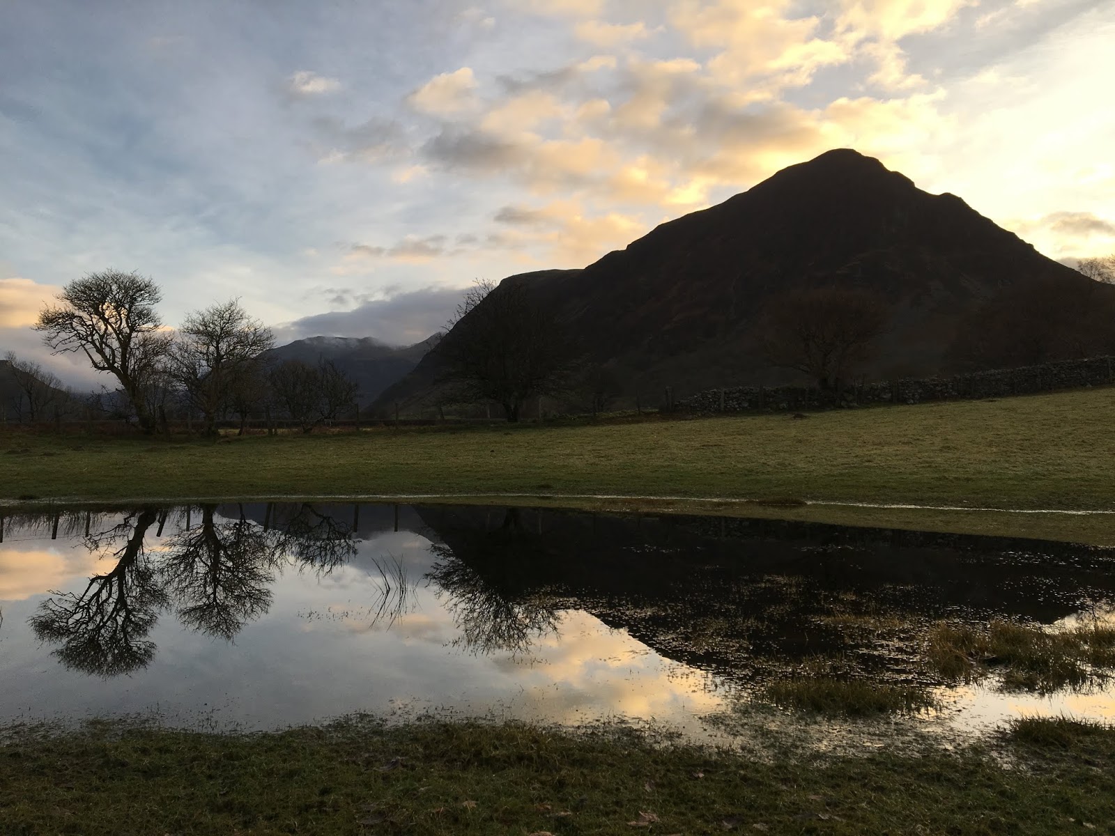
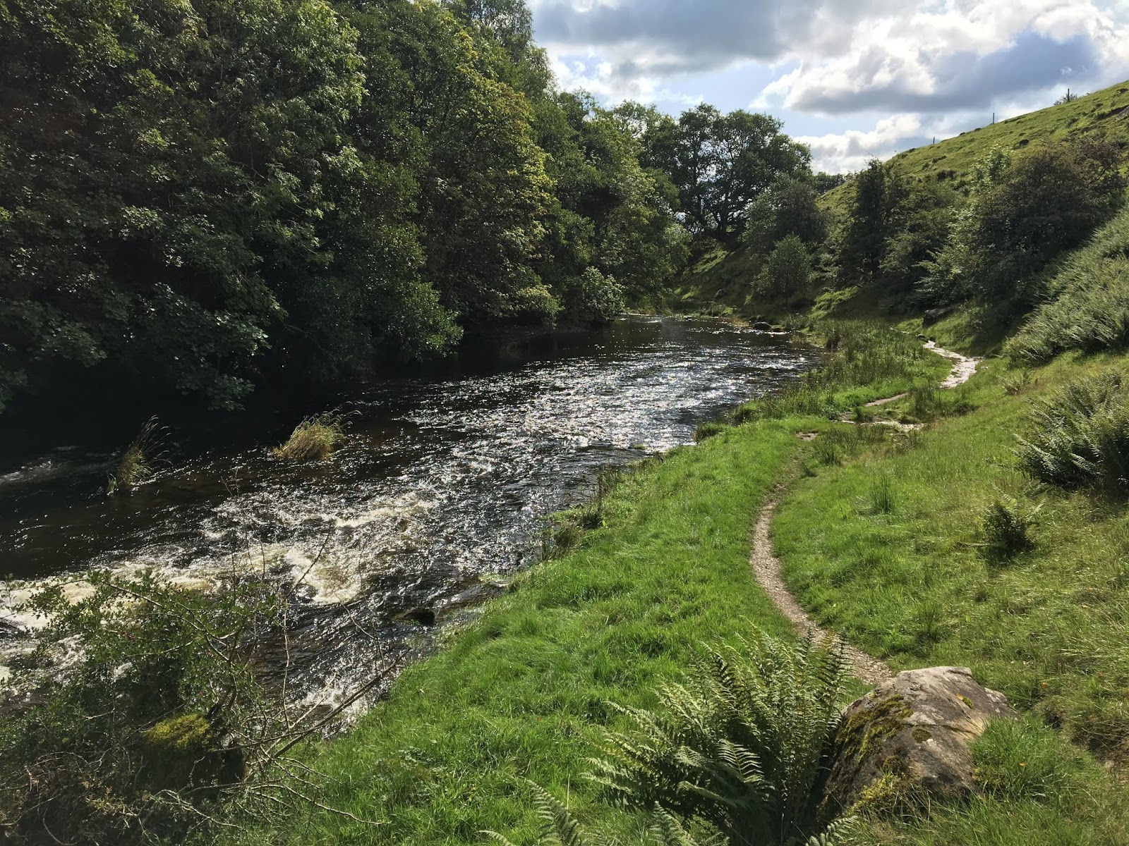
Route: leaving the cars in the northern White Moss car park and crossing the road to walk through the woods to the new wooden footbridge at the western end of Rydal Water. Then crossing the bridge (gate recently vandalised with a chainsaw) to walk up to Loughrigg Terrace and turn right to take the steep, direct route up to the summit just before Red Bank. Heading east off the summit following intermittent, eventually waterlogged paths steeply down to regain Loughrigg Terrace and follow it left (west) until the fork down to the wall-gate back into the trees and down to the other footbridge and back to the car park.

Conditions: high cloud with spits of rain to begin with but wide views on the summit

Pub: the Badger Bar for Hawkshead Red, Corby Blonde and cups of tea and pop for the others!

28 December 2018

Crummock Water to Kirkstile Inn saunter

An epic 6km journey of discovery following the unexplored waterside trail upriver to Crummock Water.

Route: leaving the car at the Lanthwaite Wood National Trust car park and, for the first time, climbing a riverside fence out of the car park to follow a wooded path running beside the rushing river to the weir at the north end of Crummock. Then via the Pump House and Low Park on paths and the road beside Park Beck to the Kirkstile Inn for lunch with Mike and Janet Hornby. Back via Gillerthwaite, Muncaster House, the Pump House and the same outward riverside route.

Conditions: before lunch, low cloud shrouding the hills. After lunch, blue skies and late sun.

Pub: the Kirkstile Inn, Loweswater, for Cumbrian Legendary Ales American Pale and Esthwaite Bitter and lunch with Mike and Janet.

27 December 2018

Eagle and Sergeant’s Crags

A surprisingly arduous 12 km walk on an empty 27 December day in the North Lakes.

Route: leaving the car in a lay-by approaching Stonethwaite and crossing the river to walk south-east on a substantial stony track with growing views of Eagle Crag. Crossing back over the river and turning left on a subtle marshy track keeping parallel with the river but, after a gate, trending right and uphill (possibly too soon) to cross another wall and then follow a clear path to the ridge. Here crossing a stile whose foot plank was secure but hand rail swung alarmingly back over the steep hill behind. Following a clear path up and turning left to climb a wet but secure rock staircase with no sense of exposure to turn right on a white quartz track with a bit more sense of the space below. Then taking a zig-zagging marshy path between rocky bands with a couple of slightly nervy staircases crossing bands to reach the summit. Then along a broad marshy ridge to Sergeant’s Crag. On for another 500m and deciding to turn right (probably too soon in hindsight) to try to find a Mark Richards’ pathless descent to Tray Dubs. Then having to contour round the hillside so as to escape obvious crags and eventually roughing it down steep, slippery and occasionally rocky grass to the valley bottom with much cursing. Joining the Cumbria Way and following this back, stopping to look at Black Moss Pot, and, much further on, cross the river west to follow a clear but stony track back to Stonethwaite and the start.

Conditions: low cloud and muted colours and but no actual rain.

Pub: the Scafell Hotel, Rosthwaite, for Jennings Sneck Lifter.

26 December 2018

Ling Fell and Sale Fell

A 12km run with uphill walking interludes on Boxing Day, once Angie and Alistair had left.

Route: leaving the car at St Margaret's church near the Pheasant Inn and running along the road to Wythop Mill and on to the green lane Green Lonning, rising and circling underneath Ling Fell. After a short descent, taking a left turn on a footpath rising to join a track and following this to reach access land. Shortly after, taking a left turn on a faint path and making up an ascending zig-zag from available sheep tracks through gorse to reach grassy hillside and following this to the top of the ridge. Crossing a fence to find a clear path to the trig point. Turning left by 90 degrees to descend to find a clear track heading yet further left and following this to within 200m of the wall and bending right and then left downhill to join the Corpse Road and clear run down to Eskin. Descending to the informal parking area and then gently uphill on a road to Kelswick before turning almost 180 degrees to follow a clear path to gain the end of the ridge and then by a combination of running and walking, gaining the summit. Heading east to Lothwaite and then descending on a large clear grassy path between bracken to the church.

Conditions: cloudy and windy with a hint of rain but not cold.

Pub: the Pheasant Inn, Bassenthwaite, for Coniston Bluebird and Cumbrian Legendary Ales Loweswater Gold.

25 December 2018

Coledale Beck and Stonycroft Gill circuit

A 12km run with uphill walking interludes to work up an appetite for Christmas dinner.

Route: leaving the car on the road in front of Middle Ruddings and running through their garden to turn right on the minor road behind heading north to Spring Bank to find the valley path to the west of Braithwaite How as far as the Tibetan Bridge and then climbing the road to reach the start of the path heading south west above Coledale Beck. After 4-5km, crossing the beck on stepping stones and walking up hill first on the main track and then turning left on a clear grassy, possibly ex-tram, path zig-zagging to meet the track descending from Sail, past High Moss under Outerside and down the valley of Stonycross Gill on an improving and rather delightful running track eventually joining the road under Barrow. After 200m heading gently uphill on a lovely path above woods to Braithwaite Lodge and then directly back to the start.

Conditions: still and dry but in very low cloud, running up into mizzle and down again, meeting 3 people in two hours!

Pub: joined by Angie and Alistair (for Christmas evening), Middle Ruddings, Braithwaite, for Hawkshead Sundown and Fell Proper Crimbo.

24 December 2018

A circuit of upper Lorton Vale including Fellbarrow and Brackenthwaite Hows

A 21km walk starting late after some emergency Christmas grocery shopping.

Route: from the cottage to Low Lorton along the road, across the river and rising past Low Bank Farm and High Bank on a green road rising onto the shoulder of the hill ominously passing a farmer gathering holly (who might have barred our non-right-of-way). Taking a track south, at first muddy and then grassy to reach open access land. Then steeply uphill to reach Hatteringill Head and descending and ascending to reach Fellbarrow. Keeping to the (undulating) summit ridge to Low Fell and then descending into the comb to the south. Following a sheep track becoming a clear - perhaps ex-tram - track to reach a partially tarmac track down to the road and thence to the Kirkstile Inn. After a pint, along the road to Scales and turning right to reach Robin’s Steps and the top of Brackenthwaite Hows then experimentally descending a ridge north-east bearing left before the end to reach the footpath, cross the road gaining the under-fell path back to High Swinside Farm and then home.

Conditions: brilliant low but surprisingly warm sun but with frost under foot.

Pub: the Kirkstile Inn, Loweswater for Cumbrian Legendary Ales American Pale and Loweswater Gold.

22 December 2018

Circuit above Brigsteer

A 7km+ run onto the Scar from Brigsteer.

Route: leaving the car in a large layby (space for 10+ cars) north of the village and running back, south past Brigsteer on the lower road but branching left on a footpath signed St John’s Church just beyond the village. Uphill across a couple of fields to turn right on a track and then branching diagnonally left off it across the large field to Helsington Church. North to the entry to the Scar and this time along the most western path along the scar to the large cairn (Dave’s Cairn) and down to Barrowfield Farm. Right then left to take a footpath descending through trees and across pastures eventually to strike a very quiet minor road. Left along this to reach the main Brigsteer-Underbarrow road and back to the start.

Conditions: cloudy with dark clouds to the north. A rainbow.

Pub: The Rifleman’s, Greenside, for Greene King Abbot Ale (hurrah!).

16 December 2018

Staveley 8km run

An 8km run on a wintry day.

Route: leaving the Staveley Mill Yard via the foot bridge over the River Kent and taking the muddy path over south east field in the direction of the sewage works. Turning right along the road and then left 400 yards later on a steep drive before crossing a stream below a small waterfall at Side House and rising gently onto the edge of the fellside. Then turning left through Birk Field farm to join the minor road north and following this up the valley on road and track to Ghyll Bank, turning left descending over fields doglegging left-right across a road, to reach Elf Howe and then the bridleway and farm track to reach the road to the rear entrance to the Mill Yard.

Conditions: grey but high cloud.

Pub: the Hawkshead Brewery, Staveley joined by Andrew and Diane for lunch and for Hawkshead WPA and Jester.

9 December 2018

High Rigg

A 9km run on the best day of a three-day birthday weekend.

Route: leaving the car at Rough How Bridge despite its formal closure at one end, at least, because of the United Utilities pipework and ignoring footpath closed signs to follow the lower of the two (perfectly unblocked) north-east paths keeping underneath High Rigg, past Shaw Bank and along a metalled road. Taking a clear path rising off the road gently to cut the corner onto the track rising steeply to the church (walking) but taking a grassy track off and uphill to the right before it. Proceeding walking (the steep bits) and running to the summit of High Rigg and then along clear sometimes marshy paths all the way along to Wren Crag and then descending to the road. Crossing the A5091 to Bridge End Farm and following a footpath north, back over the river to Smaithwaite (and a disused pub) and then on a large forestry track under The Benn to Shoulthwaite Farm recrossing the A5091 and back to the start.

Conditions: wintry but dry with high clouds and some hints of sun. Muddy under foot.

Pub: Tweedies, Grasmere, for Thornbridge Galaxia, Turning Point Rising Tide and lunch.

8 December 2018

Brackenthwaite Hows

A short 7km late morning run anticipating a poor forecast for the rest of the day.

Route: leaving the car at the once phone box now defibrillator on the way to the Kirkstile Inn and running back to the Lanthwaite Wood NT car park where turning sharp left to climb to Robin’s Steps and hence along the subsidiary ridge to the summit of Brackenthwaite Hows. Descending south through woods and then curving left and then right eventually to the boathouse on the shore and then round the lake past the, today-submerged, swimming beach as far as the pumping house. Turning right and along the river to a slightly raised track and then by a walled stony riverside path to reach Lowpark and almost Park Bridge. Here, for the first time, heading south along a path through Flass Wood to reach the familiar under-Melbreak path and round it to descend to the Kirkstile for beer. Afterwards, walking back to the car in the now-steady rain.

Conditions: initially cloudy and breezy but rain slowly increasing.

Pub: the Kirkstile Inn, Loweswater for Cumbrian Legendary Ales American Pale Ale and Langdale.

7 December 2018

Latrigg

A quick, short 7km stroll post lunch on an iffy birthday day.

Route: leaving the car in the B&B quarter in Keswick and crossing the footbridge into Upper Fitz Park to take roadside footpaths to Briar Rigg and then turning right along a track to cross the A66 and ascend. Taking the first right turn along a track and at a four-way junction continuing on on the higher path under the fellside as far as a small cross roads where turning left on a steep zigzagging path up hill, eventually becoming a straight steep tramp uphill out of the trees and onto still steep grassy fellside. Crossing a barbed wire fence with care and then along to the ambiguous top of Latrigg. Then back north west on a very clear, well-maintained zigzagging path to join the Cumbria Way and thence back to Keswick.

Conditions: some initial rain giving way to cloud and high wind.

Pub: the Square Orange, Keswick for Corby Oktohop Black IPA.

25 November 2018

11km Loughrigg Circuit

An 11km run with Steve M on his annual November visit (having spent the previous night in Lorton).

Route: leaving the car in the White Moss car park (£2 per hour) and crossing the road and then the river on a footbridge and along woodland paths climbing to reach the start of Loughrigg Terrace. Along this and then the higher track, at the end, through trees to reach the summit of Red Bank. Descending, left, to reach a track round the north of Loughrigg Tarn. Part way along taking a footpath on the left across fields to meet a stony walled track rising and turning to circumnavigate the hillside rising to reach a spur and following a grassy path, right, to reach Lily Tarn. Descending on a grassy, muddy path to reach the main track over Loughrigg and here turning left and uphill for 100m to find a path on the right descending to the Under Loughrigg road and along this towards Grasmere. Turning left, before the road re-crosses the river, onto a rising road then shady track to reach views of Rydal Water. Taking the lower lakeside path back to the initial woods and thus recrossing the footbridge and back to the start.

Conditions: cold but mainly high cloud.

Pub: the Badger Bar, Rydal, for Barngates Red Bull Terrier and Handsome Blonde.

24 November 2018

Grisedale Pike and Hopegill Head from Whinlatter Pass

A solitary 2.5 hour, 10km walk while Lois was on a theology course.

Route: leaving the car in the free parking area to the south of the Whinlatter Pass just above the two cottages. Walking along the route of the C2C on a forest track to a point where a wide path heads right with a post (N78) and leading uphill, eventually reaching the edge of forest and then along a clear, well-established path on an increasingly distinct ridge up to Hobcarton End. Then along the broad ridge to Grisedale Pike. Descending and re-ascending to reach Hopegill Head and down the greasy and slightly worrying rocky ridge to Ladyside Pike. Down the broad grassy ridge and at the first fence heading right steeply down tussocky grass to the valley. Then left through two gates and along a forest track, spurning a left turn and then U-turning to climb gently for 1km and down to the start.

Conditions: cold and windy but clearing with some late sun.

Pub? much later, after picking up Steve M from a train at Penrith and Lois in Keswick, the Pheasant, Bassenthwaite for Cumbrian Legendary Ales Loweswater Gold.

18 November 2018

Wansfell Pike and Wansfell from Troutbeck

A fine short 10km walk as a last minute replacement for a planned walk from Grasmere given delays on the A591.

Route: Leaving the car parked just over the river at the bottom of Troutbeck (perhaps 50m up the road) and taking Robin Lane round to the south of the fell, keeping with the lower track round to High Skelghyll. On entering the wood, taking a path rising diagonally eventually to reach the observatory and the ridge to the summit. For the first time taking a path to the left and higher than the normal route, gaining the ridge sooner.  Thence along the boggy ridge to Wansfell and then down the path to Nanny Lane and back to Troutbeck.

Conditions: a sunny day with an almost cloudless blue sky and ridiculously warm for late November.

Pub: the Watermill, Ings for Theakstons Old Peculier and Windermere Bad Dog IPA.

4 November 2018

Cockermouth stroll

A small 5km stroll on impulse from the Aldi car park while waiting for the shop to open.

Route: leaving the Aldi car park and climbing some steps to reach a gravel section of old railway. Following this south east as it became a snicket between houses and then ran beside a car park to cross the A5086 and rejoin a more obvious line of track, crossing a viaduct, passing underneath Lorton Road and heading out of town. At a natural terminus, turning right on a Sustrans route and then entering a cemetery pausing to watch red squirrels darting about in rude health. Then crossing Lorton Road to head through a housing estate and down onto a path beside the Cocker. South West on this across fields to a footbridge and then along the other side of the river, in a park, underneath the viaduct and regaining the track by steps, joining and crossing the A5086 and back along the initial outward track.

Conditions: high clouds and a thin blue sky to the north while the central Lake District was in cloud and rain.

Pub: much later on the drive home, Tweedies, Grasmere for Hawkshead ITI and Fell Golden Goldings and lunch.

7 October 2018

Buttermere Saunter

A short stroll with Ian R, with sports injury and head colds.

Route: leaving the car at the NT car park in Buttermere (free for members) and walking through Wilkinsyke Farm and down the lake east side of the lake shore as far as the tunnel. Then exploring a path over the top of the tunnel and back through it again. Turning back for a spot of lunch at the pub to avoid over-taxing Ian’s hamstring tear.

Conditions: cool and cloudy with rain at the very end.

Pub: the Bridge Hotel, Buttermere for Jennings Cockerhoop, Tirril ** and **.

6 October 2018

Blencathra via the East Ridge of Bannerdale Crags and then Souther Fell

A fine 12km walk with Ian Rawe, having just picked him up from Penrith Station.

Route: leaving the car just south of the Mungrisdale village hall and crossing the footbridge to walk past the pub and along a muddy track north of River Glenderamackin. The path obviously having been washed away (and mechanical diggers clearly doing repair work), picking a very damp route just above the gorge of the river to reach the continuation of the, now gravel, track. Spurning the good advice from the group to take a lower path by the river and instead diverging from it on the Bowscale path, later forcing a damp route back across bracken then to cross Bannerdale Beck and then ascend a clear path on a grassy ridge, gradually steepening to the main ridge with evidence of slate workings and onto the top of Bannerdale Crags. Thence on grassy paths past Foule Crag to the summit of Blencathra and down Scales Fell on a re-engineered zig-zagging path, up onto Souther Fell to the summit and bushwhacking steeply down hill to the east to find the graded descent path.

Conditions: improving all day to become sunny and warm.

Pub: the Horse and Farrier, Threlkeld for Jennings Sneck Lifter and Cumberland Ale.

30 September 2018

Kendal to Staveley 10km run

A 10-11km run from Kendal station to Staveley station (taking a shortcut to fit in with the Sunday train timetables).

Route: taking the train to Kendal and running along Sandes Avenue and Maude Street, across Noble’s Rest to cross Low Fellside, Serpentine Road and Queen’s Road up Stoney Lane and then along the Tram Way to Cunswick Scar but turning left and west before the summit to descend to Cunswick Tarn then to Fell Gate and Capplerigg Lane. Across the Crook Road and then north on damp paths past Knott Hill and Ashes to Staveley.

Conditions: initially rather grey and uninspiring but mild, giving way to two periods of rain and the odd burst of sunshine.

Pub: The Eagle and Child, Staveley, for Corby Blonde and Keswick Brewing Company Keswick Gold and a light lunch.

23 September 2018

Sale Fell

A surprisingly fine 10km run on the way home to return a hire car before its pumpkin hour.

Route: leaving the (hire) car near the Pheasant Inn and running along the road towards Wythop Mill, discovering that footpaths on Forestry Commission land were closed and hence quickly re-planning, passing through Routenbeck to turn right down a poorly marked set of footpaths past Rigg and East House to regain the road at Wadcrag. Along the road for a couple of kilometers past Wythop Mill to Brunston Bridge and then nearly as far as Kelswick before turning almost 180 degrees to follow a clear path to gain the end of the ridge and then in a combination of running and walking, gaining the summit. Heading east to Lothwaite and then descending on a large clear grassy path between bracken to close to the church between Routenbeck and Wythop Mill and then almost entirely down hill to the start.

Conditions: some sun and cloud but with a cold north easterly wind on the summit.

Pub: the Pheasant Inn, Bassenthwaite, for Cumbrian Legendary Ales Loweswater Gold and Coniston Bluebird.

22 September 2018

Rannerdale Knotts

A 9km evening walk after the crowds had gone home.

Route: leaving the car at the first car park on the left (heading south) underneath Grasmoor and walking along the clear track to Rannerdale to reach the footbridge to cross the stream and return to the pitched path from the road up Rannerdale Knotts. Along the summit ridge, meeting only two people, to descend into Buttermere and to the Bridge Hotel for a beer. Afterwards, taking a wet, but this time happily not actually flooded, path behind the campsite to reach the shore of Crummock Water and thence the rising path over the lower shoulder of Rannerdale Knotts and then along the road to the car as the light departed.

Conditions: still, warm evening sunshine and views long beyond the Solway

Pub: the Bridge Hotel, Buttermere, for Jennings Cocker Hoop

16 September 2018

Last 10km of the Dales Way run

A run back along the last 10km of the Dales Way (well, from the station) covering much of this ground for the first time since 1987.

Route: leaving Windermere station and heading through Lakeland's carpark to the road behind, running steeply up it to the A591 and along this, east for 100m to a footpath across damp fields to cross the railway. Then through housing following an intuitive line to join a tarmac track and following this across a number of streams, ignoring left turns up School Knott to join a stony track ascending onto higher ground. At an obvious junction bending left signed to Hagg End and gaining higher ground. Then turning half right at a subtle sign to reach a high-point with views back to the central fells. Descending to cross through Hagg End, turn right on a road and then the second left path at Outrun Nook eventually reaching and joining a familiar road. Descending and then steeply re-ascending before descending via a path to the left into Staveley.

Conditions: surprisingly warm after a cool and very wet start to the day.

Pub: the Hawkshead Brewery Beer Hall, Staveley, for Hawkshead WPA, Session IPA and lunch before a train home.

9 September 2018

Lost Lake

A walk with James to the wrong lake caused by an early navigation error.

Route: leaving the car at the Park and Ride carpark in Nederland and taking the free shuttle bus to Hessie Trailhead. Proceeding along a broad stony track to a further trailhead and then gradually rising with the valley before eventually arriving at Lost Lake. After circumnavigating the lake on small paths, descending the same way with rain arriving as we waited for the return shuttle.

Conditions: initially hot and sunny giving way to rain at the very end of the walk with some thunder.

Pub: the Very Nice Brewing Company for Very Nice, Logical Fallacy (stout) with and without espresso shot and Royal We IPA. Afterwards, taking a ride on the Carousel of Happiness.

7 September 2018

Pawnee Peak

A planned 16km linear walk to a 12,943ft summit, extended to 20km because the trail head carpark was full.

Route: leaving the car at the Brainard Lake carpark because the Long Lake carpark was already full at 10:30am (on a Friday) and thus walking by the lake and then on paths to the Long Lake trailhead. Taking the Pawnee Pass Trail through a forest of spruce and pine on soft ground with initial views of Long Lake. Turning right to spurn the Jean Lunning Trail and slowly gaining ground with occasional views into the head of the valley. At some altitude above Lake Isabelle ignoring the trail onwards and turning right to climb increasingly out of the trees, on rockier ground and in a series of switchbacks to reach a first shoulder, a bare rocky plateau, with fine views of surrounding mountains. On a second set of zigzags gaining the next shoulder and then gradually ascending to a sign marking Pawnee Pass. Here finding a faint path with some cairns to climb the gentle slop of Pawnee Peak with mercifully no false summits. Descending the same way with dark clouds ahead but no rain experienced.

Conditions: For the first half of the day, sun and blue skies though not too hot. On the descent, darker clouds and evidence of rain and even hail near the trailhead.

Critters: seen: chipmunks, marmots, squirrels and a bluebird; (heard but not seen) pikas - lots of

Pub: the Upslope Brewery at Lee Hill Drive, for Upslope Yuzu Zest IPA, India Pale Ale and nachos with both hot green sauce and salsa.

6 September 2018

Blue Lake

A 10km high altitude valley walk to a lake (11,338ft) surrounded by rock scenery.

Route: leaving the car again at the Mitchell Lake carpark (the previous $11 per car to enter the park covering 3 days). Taking the Mitchell Lake Trail and slowly ascending an easy path through trees with views to left and right of small lakes, climbing to an area of less vegetation with views of the broader rocky valley and eventually arriving at the foot of Blue Lake. Following a smaller track continuing round the lake counter-clockwise to an outcrop at the far end looking back over the lake and then a little further beyond to the next tarn up the valley. Seeing no continuing trail round the lake, retracing our steps.

Conditions: initial blue skies and sun, though cool at 10,000ft but, on the descent, cloud and rain coming in and on the drive back: hail.

Critters: (seen) deer on the drive in in Lefthand Canyon, chipmunks and a big brown moose grazing beside the road on the drive out, just by Brainard Lake; (heard but not seen) marmots

Pub: the Asher Brewery, Gunbarrel (Boulder), for Tree Hugger Amber and Green Bullet IPA (and crisps!). The Avery Brewery, Gunbarrel, for Go Play IPA, Avery IPA, Double Dry-Hopped IPA, and Hog Heaven Imperial Red IPA and giant pretzel with nacho cheese sauce.

5 September 2018

Mount Audubon

A high altitude 13km walk on a day of threatening thunder, to a summit of 13,223ft.

Route: leaving the car about 6 very slow miles, on lovely smooth but twisting roads, beyond the 9,000ft altitude tiny town of Ward, at the Mitchell Lake carpark ($11 per car to enter the park). Taking the Mt Audubon Trail from the corner of the carpark and following this first along a level path through trees, then gaining altitude in zigzags with the trees thinning and fine views over the valley. Eventuallly climbing onto a higher plateau, passing a fork in the trail and continuing on rougher stony but clear paths across more desolate landscape, gaining further altitude eventually to reach a shoulder about 500m from the summit. Picking a tricky route through boulders (and with a worryingly high heart rate) to the summit to the sound of occasional claps of thunder. After a brief pause, returning the same way with the rain now increasing to full on Cumbrian weather.

Conditions: initially cool, mainly cloudy but with some patches of sun. Later, developing thunder some distance away. Finally, persistent rain.

Critters: (seen) lots and lots of pikas, one or two marmots and deer on the descent

Pub: the Upslope Brewery at Lee Hill Drive for Upslope, Blood Orange Saison, India Pale Ale and some nachos with a hot green sauce.

3 September 2018

Boulder Foothills and Reservoir run

A run on Labor Day to avoid predicted crowds in the parks.

Route: leaving the car at the Foothills Trailhead (a small car park but fairly empty at 11am on Labor Day) and running north to the start of the trails. Taking the Eagle Trail and then Cobalt, though obviously getting lost and needing to pick our way down a slight hill to find the trail again, and hence  to another trailhead parking spot. Along Sage and Eagle to 51st St (a dusty gravel road) and along this, now at a walk, to the road to the Reservoir Complex ($7 for swimming) for a swim in a tiny patrolled section of the reedy reservoir. Then back the same way to start on Eagle, spurn Sage and bend left past an almost pretty tarn, gain ground, cross a barren minor valley and eventually return (via Degge Trail) to the start.

Conditions: surprisingly cloudy with rather flat light but warm enough to swim outdoors and teeming with very squeaky critters!

Critters: (seen and heard all around all the time) prairie dogs

Pub: the Upslope Brewery at Lee Hill Drive for Upslope, Yuzu Zest IPA, India Pale Ale a taster of Southern Hemisphere Double IPA (and some nachos).

2 September 2018

South Boulder Peak via Shadow Canyon Trail

A steep 14km hike through varied terrain to a fine view.

Route: leaving the car at the South Mesa Trail Head ($5 parking, lucky to get a space at 10am on a Labor Day Weekend Sunday) and taking the Mesa Trail. Sadly, almost immediately going wrong by taking a left turn too soon onto Homestead Trail and then being further unnerved by too reports of an angry (contrast, eg., perky) rattle snake. Despite this following this trail round, gaining ground and eventually rejoining the Mesa higher up. Turning left onto the Shadow Canyon Trail which rose steeply though on a broad graded track until it became single track and entered the canyon proper on a steep path over roots and boulders though clear. After 3 km reaching a shoulder where turning left for a rocky path and final easy scramble to the summit of South Boulder Peak. Descending the same way as far as the bottom of the canyon and then turning left on a narrow track, with steep slopes to the right, heading to the Mesa Trail and turning right on this eventually to rejoin some of the outward route but continuing to pick up Towhee Trail and follow this to the start.

Conditions: the originally forecast rain having been revised away, a warm sunny day though not too hot in the canyon nor on the ridge.

Pub: the Southern Sun Pub for Mountain Sun Brewery Annapurna Ale and Illusion Dweller IPA (and nachos with salsa and guacamole).

1 September 2018

Mount Sanitas

A first day walk up Boulder’s Latrigg (6843ft, 1343ft of ascent! Ed.)

Route: heading north form the apartment at 2301 Pearl St on Spruce Avenue, past the centre of town, as far as 8th St and then heading north to Mapleton Ave and hence west to the trailhead for Sanitas Valley Trail. Taking this but after a short distance turning right for the Dakota Ridge trail which kept under the ridge itself. Hence heading right to the ridge on a clear but informal path and following this to the end of the valley. There descending a short way and taking a zigzagging path, surprisingly rocky in parts steeply up to a crowded summit of Mt. Sanitas. Descending a still tricky under foot path back down the ridge to a trailhead and then taking the Red Rocks Trail descending through Settlers Park to the top of Pearl St and thence home, eventually joining Spruce St.

Conditions: warm and muggy and some very light warm rain.

Pub: the Post Brewing Company for Post Townie Ale and Otter Pop as well as a light lunch.

Boulder Creek path and Pearl St run

A 7km run on the first morning in Boulder.

Route: leaving the apartment in 2301 Pearl St and heading south on 23rd St, west on Walnut St and south, again, on 22nd St to find a path leading to the Creek Path. Following this along to Central Park and then Eben G Fine Park crossing the creek and then recrossing back over the creek and under the 119 to reach the top of Pearl St and following this home.

Conditions: even at 8:30am, a warm day.

Pub? Not at 9am!

(This run repeated on 02.09.18)

25 August 2018

Dales Way-based 9km circuit

A 9km run mainly off road.

Route: from the Staveley Mill Yard, west along Kendal Road to the left turn onto the Dales Way just before the level crossing and following paths across fields to run along the river bank past Cowan Head to Bowston where the route joins the road. Turning right on a road to Bowston Farm and then along a track parallel to and then crossing the railway line and eventually carefully across the busy A591. Through woods to Ashes Lane and on this past the camp site (where tarmac gives way to track). At the point where the route back to Kendal joins from the woods, striking out across the field to a footpath sign and then across fields to cross the A591 again and more fields before crossing under the railway. Then back to the start.

Conditions: a sunny day though cool for August.

Pub: Hawkshead Brewery, Staveley for Hawkshead WPA.