28 April 2020

Trip to see bluebells

An 18+km evening cycle ride to see the bluebells south of Staveley.

Route: leaving the house and heading along Valley Drive, through the Castle Estate to the river side path to Burneside Road and along this to Bowston, turning right over the river to join the back road to Staveley. Stopping at the junction with Potter Fell High Road to look at the bluebells and then returning via the Mintsfeet industrial estate and back through the centre of town.

Conditions: 7C and initial drizzle becoming light but constant rain and hence chilly after the 4 weeks of sunny weather.

Pub? (C-19) T drank half a bottle of Abbot without any ceremony while cooking.

26 April 2020

Cunswick Scar

A novel 7+km variant run round and onto Cunswick Scar.

Route: leaving the car parked on Queen’s Road near the Tramway and running down the road to a footpath left opposite Low Fellside and, for the first time, following this very slightly uphill across fields below Kettlewell Crag and Helsfell Nab. At a farm building bending left uphill to run back parallel with, and above, the cutting on the A591 to reach the footbridge. On the far side, taking a lower path than the direct route to Cunswick Scar to pass Helsfell farm, join the farm track down towards the road and then diverge from that across fields to join the Crook Road at Plumgarths. Along the road taking the second path on the right and across a couple of fields before recrossing the road and running into bluebell woods and eventually onto the top of Cunswick Scar. Back down to the footbridge and then across the golf course staying - unusually - on a track to the top of Serpentine Woods, there bending left to descend to the top of the Tramway and back to the car.

Conditions: after many days of sunshine, a cloudy day though not cold.

Pub? (C-19) Bottled Abbot Ale in the summer house.

25 April 2020

Cycle circumnavigation of Scout Scar

A 30+km cycle ride on the last of a long series of hot sunny days.

Route: from home to the new Stonecross Meadow housing estate to pick up buttons for charitable purposes and then through town, dodging the zombies, up Windermere Road and right into Hallgarth to deposit them with Linda. Taking the footpath over the railway line between Low Mead and Briarrigg and then along Burneside Road to Burneside and left up the very steep Sharps Lane (pausing to look at a pond with ducklings) to cross an empty A591 and proceeding along Ratherheath Lane pausing at Ratherheath Tarn, recently re-engineered to enable access for wheelchair-using anglers (it looks terrible, sadly), to join the Crook Road. Left off this for a fine descent to Underbarrow and then along the side of the valley to Brigsteer, staying low and thus facing a very steep climb at the end of the village. Thence to junction just north of Levens and the easier ascent of Sizergh Fell before our standard route back via Natland, pausing to admire a large rootling pig and the river at the bridge over the Kent before Sedgwick.

Conditions: hot and sunny, clouding over and then clearing again.

Pub? (C-19) Bottles of Hawkshead WPA and Henney's Dry Cider in the summerhouse.

24 April 2020

Industrial archeology and the Matterhorn, east of Kendal

A 5+km run to investigate some points of interest east of Kendal.

Route: leaving the car in a layby by the Castle Green Hotel and runing due east and uphill in a narrow enclosed snickleway pausing, where it opened out, to explore industrial ruins (including a chimney) in Spindle Woods to the right. Across the railway and then, cheekily, trespassing off-path to the left and uphill, through a gate and onto the highpoint which, we surmised, is the local Matterhorn as seen from Oxenholme Station. Heading back towards the path alongside and underneath the imposing remains of a dam wall and then, legally, crossing fields to reach Paddy Lane. North along this to a signed track downhill towards Kendal and turning left off it on a footpath to explore "Second Res", a partially full disused reservoir. Then west downhill across the subtle remains of "First Res" through an underpass designed for midgets and left along the work being done shoring up the railway embankmant to reach old Sedbergh Road. Down this and left uphill to the car.

Conditions: bright sun and very warm for the time of year (18C).

Pub? (C-19) Saltaire Blonde and Moorhouse Pendle Witches Brew while chatting over the web with James and Jo.

23 April 2020

A Natland and front-of-Helm run

A 6km solitary C-19 run.

Route: leaving the close and running up Oxenholme Road and then, for the first time in ages, turning right onto the footpath across the fields to Barton Road. Left to the railwayline and then right on a footpath south which turns right towards Natland. After some confusion emerging on the road uphill under the railway line to the front-of-Helm lane. Starting on the footpath round the south of the Helm but soon turming left to head uphill and then further left to spurn the summit and slowly trend towards the lowest point of the saddle. Here taking the left diagonal descent (the third such option) but bearing right off it onto a narrow path maintaining altitude for as long as possible. then descding towards the Station Inn and home.

Conditions: very warm for the time of year (18C) though hazy sun.

Pub? (C-19) No beer. A G&T on the patio.

20 April 2020

Down memory lane to Milnthorpe

A 24km (15-mile) cycle ride down to Milnthorpe by Lois on a rest day for Tim, to visit (and deliver flour to) Mike and Dianne
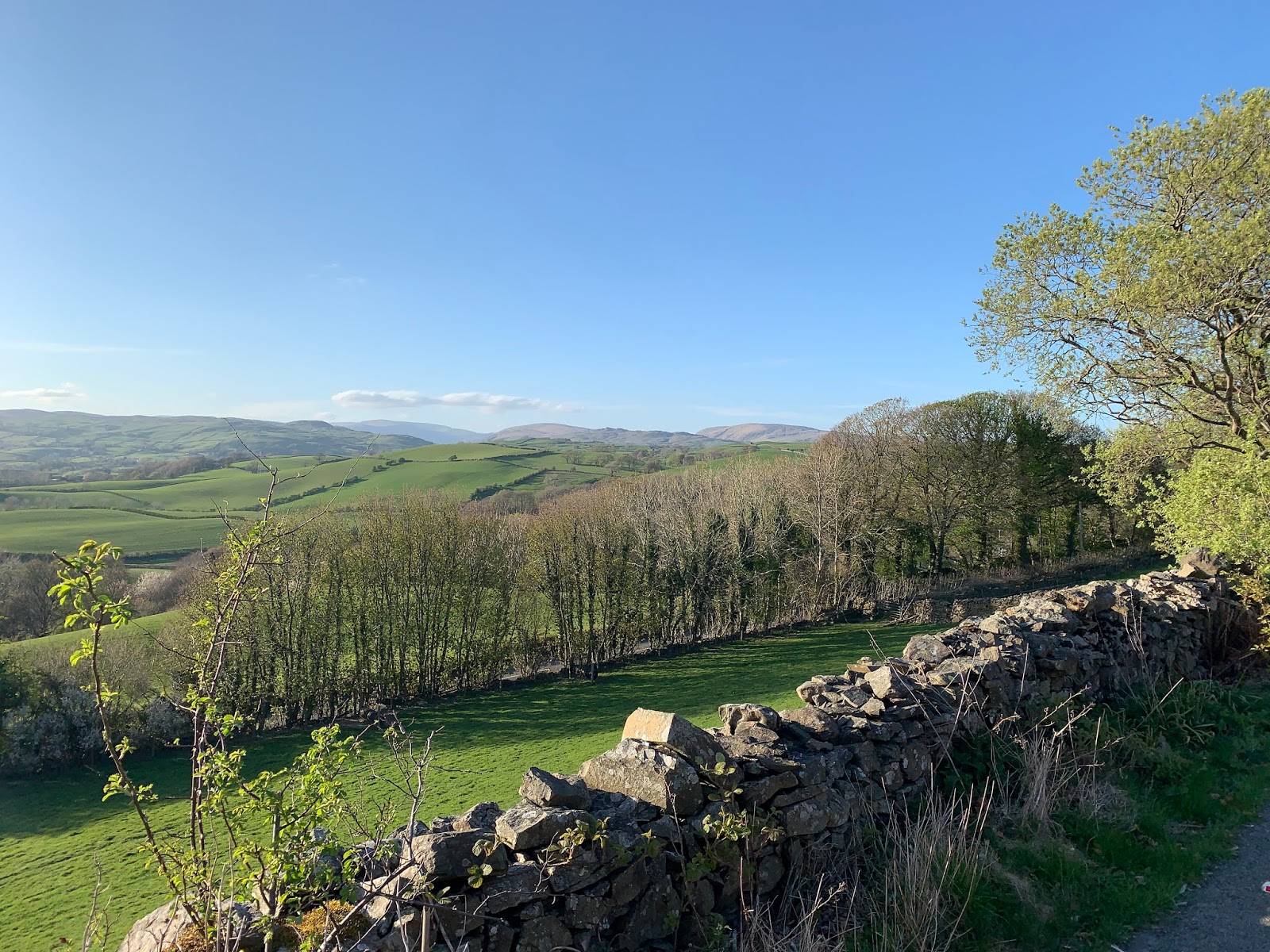
Route: Setting off from home up past the station to follow Helmside Road through Oxenholme and turn south on the A65 following it as far as Halfpenny and then turning right (south-southwest) along the lane down to St Sunday’s Beck and on down to Stainton. After Stainton crossing the beck and carrying on down to curve up and over the bridge over the canal and to Viver Lane. Following this under the A590, through Viver and under the West Coast Mainline. Doglegging through Woodhouse and then, at the crest of the hill, turning right to follow Haverflatts Lane all the way down to the main road in the centre of Milnthorpe. Looping back through Police Square (to admire Jasmine Cottage, erstwhile post room, kitchen, offices of Cicerone Press) to Harmony Hill to visit Mike and Dianne. Leaving them heading back east to the main road and staying with the B6384 at the mini roundabout, towards Holme, soon turning back north up Smithy Lane to admire the balcony at the Old Smithy (made out of railings emblazoned with the monogram of the Morecambe Pier Company and falling into conversation with its owner, Roger Bingham).
Leaving Roger heading north to cycle through Ackenthwaite and rejoin Viver Lane again this time only as far as the West Coast Mainline. Here turning left on Well Heads Lane and following this all the way to Sedgwick (crossing under the A590 and the railway again). From Sedgwick cycling back via Natland and Natland Road and the Beeches back to Howe Bank Close.

Conditions: Bright and sunny with gentle breezes on the way out and really gusty, tiring cold winds on the ride back.

Pub? C-19 Bottle of low-alcohol cider and mug of tea with Hilary and Beth in the garden at a safe distance).

19 April 2020

Helm run variant

A solitary 6km run (L exercising later) along the new-to-me under Helm path.

Route: from the Close uphill over the railway and then steeply uphill past the Station to take the road at the back of the Helm (Pye Lane) but before it descended taking a handgate by the second gate on the right. Following a Landrover track on grass diagonally uphill to the small tarn and then taking a path just higher than the outflow but descending diagonally south to meet a path running parallel to the road and joining it into the woods. Just before a handgate onto the path round the south of the Helm turning right uphill, past a bug hotel, and climbing, eventually at a walk up the steep end of the Helm but on the right (east) of the remains of the ridge wall. Then along the ridge to the northern end, back through a handgate and down the hill to the Station Inn and then home.

Conditions: sun and blue skies after the hottest day of the year.

Pub? (C-19) A bottle of Henney’s cider joined by Lois on Hawkshead WPA, in the summer house.

Finding the Matterhorn?

A solitary 4.5 mile expedition to find Bluebell Wood which may have ended up finding the elusive Matterhorn

Route: Leaving the Close to run along Hayclose Road to the end of Kendal Parks Road and there turn right towards the new houses and then left along (new) Oak Lane by the flats and on, off the tarmac, across the brook and turning right up the footpath and bending left along the crest of the little hill, right beside the railway line, and into Bluebell Wood (the wood east of Bluebell Close). Following the wide track along through the woods to its end where it runs out down to the back of houses on Littledale, there turning right under the railway line. Climbing over a makeshift fence at the far end of the tunnel and turning right to run along a little beck to the snickleway leading up to Birk Hagg and out along the drive to Singleton Park Road. Turning left there to run down the road and take the little walled ginnel signed up to Paddy Lane and Spindle Wood. At the end of the ginnel, running down to cross the railway and then bearing left across a couple of fields northeast to reach the wide grassy ridge, just south of Skyline Wood (perhaps the Matterhorn?). Tracking back looking for an easterly exit and running down and over a bridge in a wooded dip to cross another field and join the bridleway east, over three more fields, past Singleton Park farm to reach Paddy Lane. Running down Paddy Lane to the end to cross and follow Hayfell Road to the Station Inn and back down through the Glen and round the station home. (Photo shows a view of Skyline Wood from the stile on Paddy Lane, with the grassy ridge to the left.)

Conditions: Glorious clear, hot and sunny after a blistering afternoon

Pub? C-19 A bottle of Hawkshead Brewery Windermere Pale Ale in the summerhouse with Tim after his (separate) run

18 April 2020

7km Scout Scar circuit via Barrowfield and Windy Howe

A 7km run over and round the south end of Scout Scar.

Route: leaving the car at the normal car park and heading via L’s preferred route north and keeping low to strike the first wall low down and maximise the climb, alongside the wall, to the Gate in the Corner. Thence to the trig point and back along the edge of the Scar to Dave’s cairn. Descending to Barrowfield Farm and south on a path through the woods for about 1km before rejoining the farm track, dog-legging down the tarmac road just before Brigsteer to the start of a walled track and along this, under the end of Heslington Barrows as it slowly rises. Running back along the higher track to the church and then right, initially at walking pace up the final hill, apparently pathless but on a right of way across two fields to cross the road and, vaulting a gate, struggling over the Escarpment and down the usual up-route to the start.

Conditions: better than the earlier forecast: high cloud and weak sun.

Pub? C-19 bottled Abbot in the summer house.

17 April 2020

Round Hay Fell

A 19km cycle trip northeast of home on a C-19 evening.

Route: leaving the Close and heading over the railway line and up the hill to the Station Inn, turning left along Hayclose Lane, crossing the A684 at Singleton Park onto Paddy Lane and to the once-pub the Greyhound. Continuing further north gradually descending, recrossing the railway to turn right on the A685 (Appleby Road) for 2km and then right past Docker Hall and right again onto Docker Lane rising first gradually and then a lengthy hill to turn right and climb to the highest point of the trip on Dickgate Road. At the end, turning left onto the A684 and shortly right onto the very steep initial descent of Hawkrigg Lane, descending through Moss Head and then bending right on a pretty undulating lane with grass down the middle. Then left onto Beehive Lane and right on the B6264 climbing past the Station Inn and home.

Conditions: a bright, sunny evening though with a continuous cold breeze.

Pub? (C-19) Bottles of Hawkshead Red and Moorhouse Pendle Witches’ Brew in the summer house.

15 April 2020

Over Scout Scar and Sizergh Fell

A 20km C-19 evening cycle jaunt to the southwest of Kendal

Route: from the Close and down to Kendal College and then slowly ascending Vicarage Drive to Brigsteer Road, over the A591 and along the length of the Scar, descending sharply into Brigsteer. Taking the road just in front of the pub south and along the Lyth Valley at mid-height along Parkend Lane and through Brigsteer Park. At the end forking left up Sizergh Fell Road to join the main road over Sizergh Fell halfway up and swing over the top of the fell and down to The Strickland Arms and the gates of Sizergh Castle. Carrying on, under the main road to hairpin round and over the river and return home via Sedgwick and Natland.

Conditions: a day of bright sun and blue sky had given way to thin high cloud and hazy sun before we set out.

Pub? (C-19) Bottled low-alcohol cider and St Austell Proper Job.

14 April 2020

Hincaster and back

A south-southeasterly loop from home by bike during C-19.

Route: from the Close, south on Oxenholme Road and left at the traffic lights up Burton Road and then right at the Asda roundabout onto Natland Mill Beck Road but turning left almost immediately through the Beeches, onto Natland Road, and then slowly up the gentle gradient to Natland. To Sedgwick, across the A591 to Hincaster stopping to looking at the tunnel and then to Greenside turning left round the crazy new Egg Homes and back via the canal, the ridge up to Crosscrake and then right to join the A65 at Barrows Green and pedal home.

Conditions: suddenly cooler but high cloud and hints of sun.

Pub? (C-19) bottled low-alcohol cider and a can of Salt Beer Factory Calico.

13 April 2020

Hunting the Matterhorn on Easter Monday

A solitary 5-mile run (by Lois) to try and find Tim’s Matterhorn

Route: Setting out from Howe Bank Close and running up round the station (failing to nip in to remind myself of the object of the search first – doh!) and up to Hayclose Lane and along to Paddy Lane. Just past Singleton Park climbing over the stone stile at the sign to Parkside Road and running down across three fields (through about 20 lambs having an evening top-up feed) – eyeing up the wooded hillock to the left (without a mast) to the bridge over the railway line.

Crossing the bridge to look up at the mast behind the Castle Green at close quarters (definitely a mast but surely not enough of a Matterhorn). Jogging round the boundary of the steep little field between the railway line and the mast (looking for a way through but not finding one) and then taking the narrow stone ginnel with its mini handgate down to Parkside Road.

Running down Parkside Road, turning right along Larch Grove, then left along Willow Grove to find the tunnel under the (other) railway line through to the Castle estate.  Running back to Parkside Road to cross it and then run along the ginnel under the eastern slopes of Aikrigg back to where it turns left and rejoins Valley Drive, and then following Valley Drive to the passage cutting through to the Heron and back home the usual way from there.

Conditions: a cool sunny evening.

Pub? Well C-19 and without T and Monday night so no beer at all!

12 April 2020

Journey to the spooky pit (Scout Scar)

A weekend run during the C-19 shutdown.

Route: Leaving the car for the first time at the new hand-gate midway between the racecourse and the usual parking place and ascending the wide path slowly uphill to a hand-gate to the right. Through this and to the start of the hidden valley path but, again, mistaking the route which turned out to be a little further south, more uphill and much more churned up than we remembered it. After 200 metres of more level and grassy going, and just before a descent, turning left on a faint wider path to the day's target which proved, disappointingly, merely to be a dry pond (with lots of temptingly workable damp clay). Then heading for the gate in the summit wall on fair ground, though all paths giving out. Through the gate, turning left to the trig point, then left down the hill descending parallel to the wall to the east but, just before the path zigzags up a short scree slope, bending right to follow a green track down a shallow valley. Crossing the main racecourse-to-Dave’s-Cairn path and continuing to turn right on a very clear section of the trippy path and following this to the end. Then left and descending and swinging back uphill to the start.

Weather: high cloud.

Pub? (C-19) A bottle of Greene King Abbot Ale shared in the summer house.

11 April 2020

Scout Scar 6.8km run from the racecourse

A weekend run during the C-19 shutdown.

Route: Leaving the car at the racecourse layby and running along the main diagonal path towards Dave’s Cairn but turning right before the handgate to try to enter the hidden valley. Sadly, turning right a little too soon and finding a confusing subsidiary valley slightly downhill and to the east of the main valley thus arriving via tussocky pathless ground at the main path from the racecourse to the mushroom lower than normal. Turning slowly up this path to the handgate and then turning right to hug the wall to the Underbarrow Road. Then up the gravel path onto the edge of the Scar and along this to Dave’s Cairn and then cutting across diagonally right to the Gate in the Corner to descend parallel to the wall to the Trippy Path and thence back to the start.

Weather: a glorious sunny evening.

Pub? (C-19) Cans of Big Smoke Jagged Sky, Fourpure Easy Peeler in the summer house.

10 April 2020

Popplemire and Low Park Lanes

Another short 15km C-19 evening Outdoor Day pootle.

Route: from the Close heading uphill past the station and the Station Inn descending eastwards and then climbing as far as Middleshaw. Turning right on Popplemire Lane to Holmescales and right again along the valley to Gatebeck. Turning right onto Gatebeck Road and then, for the first time, right onto Low Park Lane with views of a couple of small tarns below to the east and horses everywhere. Following the road round to join the A65 to the front-of-Helm road and then home.

Conditions: a warm hazy sunny evening.

Pub? (C-19) bottles of Saltaire Blonde and St Austells Proper Job in the summerhouse.

8 April 2020

New Hutton and circuit of Grey Crag cycle ride

Another short 15km C-19 evening Outdoor Day pootle.

Route: from the Close heading uphill past the station and the Station Inn descending eastwards. Taking the first left at Beehive Bridge, along Beehive Lane, beside pretty Beehive Beck, then the first right and over two small but sharp hills to Borrans Farm before bending left to New Hutton and left again to pass the church and then cross the A684. Rising into moorland before descending with views across the wide valley to the Kendal Hills. Turning left to climb in effect round Grey Crag along and descending back towards the A684 on Dickgate Road but, just before it, turning right on a Sustrans route, past Fisher Tarn Reservoir and left at the old Greyhound pub and thence home past the station.

Conditions: a warm sunny evening.

Pub? (C-19) a bottle of San Miguel and half a bottle of Weston (Sainsbury’s) 0.9% cider in the summerhouse.

7 April 2020

Natland and Sedgwick cycle pootle

Another tiny 12km C-19 evening Outdoor Day pootle.

Route: from the Close heading through the Kendal Parks estate (to drop off a funeral service printout to Hilary), then to the Rinkfield post office (to post some Cadas letters) and then rising gradually to Natland, along to Sedgwick where turning left over the hill to Crosscrake Church, along the A65 to the front-of-Helm road and then home.

Conditions: a warm sunny evening with lots of people out.

Pub? (C-19) a can of Fourpure Easy Peeler and bottle of Weston (Sainsbury’s) 0.9% cider in the summerhouse.

5 April 2020

Eastern ridge of the Kendal bowl by foot and bicycle

Evening exercise in two forms, at the same time: T cycling on a dramatically repaired Moulton and L on shank's pony.

Route: leaving the Close and heading separately by bike and foot over the railway lines and up the hill to the Station Inn, turning left along Hayclose Lane, crossing the A684 at Singleton Park onto Paddy Lane and to the once pub the Greyhound. Here T continuing further north gradually descending, recrossing the railway to turn left on the A685, to Kendal and returning via Castle Road and Valley Drive. L turning left at the Greyhound and descending steeply the old Sedburgh Road to Castle Green Road, and along Valley Drive and the snickleway to the west of it.

Conditions: a sunny evening though with a significant warm breeze.

Pub? (C-19) Cans of Hawkshead Route 590 West Coast IPA and (0.5%) Flathead lager in the summer house.

4 April 2020

Scout Scar 5.7km run

An Outdoor Day because run during the the Covid-19 shut down.

Route: From the layby (at GR 494899), a short ascent then bearing left to reach and then descend the escarpment and south across the fields before bending right onto the green track with views of the estuary. Bending left below Pooks Peak, through a gate and then along the cliff edge of the Scar. Along this to the trig point descending parallel to to the wall to the east but just before the path zigzags up a short scree slope bending right to follow a green track down a shallow valley. Crossing the main racecourse-to-Dave’s-Cairn path and continuing to turn right on a very clear section of the trippy path and following this to the end. Slowly uphill parallel to the wall, through the gate in the wall corner to descend, past the spooky building and along the edge of the escarpment to the start. 

Conditions: Cloudy, dry and 9C.

Pub? No because of C19, so a shared bottle of Abbot in the summer house pop-up pub.