Pub: the Coledale Inn, Braithwaite, for Tractor Shed Kessin, Corby Blonde, lime & soda, ginger beer and Appletiser (and to meet Tim and Kathryn for lunch)
31 May 2021
Blencathra via Hall's Fell and Blease Fell
Pub: the Coledale Inn, Braithwaite, for Tractor Shed Kessin, Corby Blonde, lime & soda, ginger beer and Appletiser (and to meet Tim and Kathryn for lunch)
30 May 2021
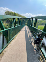
Cycle ride to lunch at Dean via the Camerton foot bridge

 A 40km cycle ride for a lateish lunch.
Route: leaving the cottage and heading north towards Cockermouth but turning right to go via High Armaside and Strawberry How and then passing the Swan on Kirkgate and left along Market Street and then High Street to turn right up Gote Brow and left on Papcastle Road. Here joining the Sustrans S71 route. Passing through Great Broughton (after a steep ascent) and then along a quiet road to Camerton with mild peril induced by passing road closure signs and the roadworks at the very end (easily passable by bike). Another steep ascent into Camerton and then left along a narrow tarmac road towards the (unseen) River Derwant and then pushing along 50m of footpath to push across the reinstated (post-2009 floods) footbridge. Then steeply uphill to a busy sunny, family-filled playground (and mining memorial) at Great Clifton and a half of lager at the fancy but real ale-free Old Ginn House. Then via Little Clifton to Dean for lunch. Afterwards, back the quickest way via Pardshaw and Brandlingill.

Conditions: a day of hot sunshine (forecast to reach 20C) but with intermittent cloud and, at one point, the look of thunder 20 miles away.
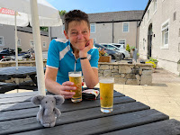
Pub: the Old Ginn House for half pints of Stella Artois; the Royal Yew, Dean for Ennerdale Brewery Royal Yew Blonde and lunch.
29 May 2021
Helm Crag

 A 7km walk before lunch with Steve, Katherine, Tom and Alex.
Route: with prior permission, leaving the car at Tweedies around 11am and walking to the centre of Grasmere and up the Easedale Road past the Lancrigg vegetarian B&B. At the end of the road, turning right onto a stony track and then right again onto the route up the Helm. Following the switch backing path eventually onto the ridge and along to the top. None of the party except Alex attempting to scale the Howitzer and he eventually deciding that discretion was the better part of valour. Descending to the next saddle and taking the clear and steep path, loose in places, directly down the hillside to the valley path. Here pausing to cool feet, and in one case fall in, before returning, making use of the Poets Permissive Path into the Lancrigg’s gardens and a corner cut to the road from Allan Bank to return to the pub for lunch only a little late for 1:30pm.
Conditions: initially cloudy but warm and becoming warmer still as the sun broke through.Pub: Tweedies for Thornbridge Crackendale, too many soft drinks to mention and lunch.
28 May 2021
Evening cycle ride to the pub in Buttermere

 A 22km round trip for a pint and to redeem a sedentary afternoon.Route: from the cottage to the mid-Lorton crossroads and turning left for Hopebeck rising gently and then descending to the main road. Turning left towards Buttermere and gently uphill to Lanthwaite Green and then mainly downhill until a final rise to enter Buttermere village. Randomly selecting the newly reopened Buttermere Court Hotel for a pint initially outside and then moving in out of the drizzle and falling coincidentally into a conversation with a Kendal cycling couple. Back after a single beer thus not trying the also newly reopened Bridge Hotel, in case T’s energy levels later slumped, along the main road along Lorton Vale.
Conditions: cloudy and eventually, a very fine drizzle.
Pub: the Buttermere Court Hotel (née Fish) for Allendale Wagtail and Corby Brewing Company APA.
27 May 2021
Castle Carrock from Lower Gelt Woods
Route: From the parking at Low Gelt bridge, crossing the bridge to head southeast down the road a short way and then bend left on a track cutting across the quarry to curl round Watch Hill to the right and then follow the bridleway through woods and along field edges for about a kilometre to reach the B road by Tootop Woods. There turning left along the road to reach Middle Gelt Bridge, walk under the railway viaduct and follow B-roads southwest and then southeast to reach the picturesque hamlet of Greenwell. There joining a bridleway to just south of High Gelt Bridge and turning right (south) to follow the road into Castle Carrock. At Castle Carrock the rest of the party stopping briefly at the pub (!) before heading off to circumnavigate the reservoir, while L headed back by leaving Castle Carrock on the road to the west and then turning up an excessively muddy/manurey lane north to get back to Greenwell. There taking the signed path along the River Gelt all the way to Middle Gelt Bridge and then following the Gelt (on the true right bank) two very picturesque kilometres back to the car park.
Conditions: Glorious (unexpected) hot sunshine and blue skies (but a bit muddy underfoot after days of rain)
Pub? Much later, Thwaites Wainwright at the Wheatsheaf Inn, Lorton, with T.
22 May 2021
Round Crummock from Rannerdale


At 15km, the longest walk in a long time.
Route: leaving the car promptly at the Lanthwaite Green roadside car park which was already 90% full (at ten past nine on a Saturday) and ascending on a faint path to the under-Grasmoor path southwards. Descending near the car parks and walking along the track to the bluebells, still in good form. Continuing up Rannerdale to the saddle and then down to Buttermere peering through windows to determine whether either pub was yet open (after Covid and refurbishment). Crossing to the far side of the valley to take the sometimes wet stony path north on the west side of Crummock. Although some streams and swamp areas had to be jumped, ground conditions were not too difficult despite recent heavy rain (becks and lakes high). At the north end of the lake, keeping on higher ground to the left to reach Lowpark and then along the road to the Kirkstile Inn, the goal of the venture. Sadly the pub being fully booked immediately continuing along the road to the NT Lanthwaite Wood car park, ascending on the leftermost path to the saddle of the hill, along the ridge and then coming off the ridge left on the path across fields back to the start.

Pub? Coniston Infinity IPA and Coast Sabro back at the ranch.
9 May 2021
Castlerigg Stone Circle and Low Rigg (and Low Hill Heights)

 A short, 6km walk loosely inspired by one of Mark Richards’ routes in his new Threlkeld Walking Companion.
7 May 2021
Brackenthwaite Hows evening stroll
 A sudden change of plan from an early evening rendezvous with a Cockermouth fish and chip shop to an evening sunny stroll in the face of a poor forecast for the rest of the weekend.
Route: leaving the car at the Lanthwaite Green NT car park and heading south to the lake along the riverside path, picking a way through tree routes, with views to Mellbreak. At the lake continuing round to the boathouse and then on further south through the woods on the lakeshore path. Halfway or so across the subsequent fields bending uphill and left and then turning left along the top wall and a little along the road. Taking the first footpath left to regain Brackenthwaite Hows and reach the summit. Down Robin's Steps.
 Conditions: a beautiful sunny evening, all the more lovely with the certain prospect of ‘heavy wind and rain’ the next day.
Pub? Bottled Booths cider (Perry’s Redstreak) at the cottage.
1 May 2021
Sale Fell

 A short walk at 6pm to redeem an afternoon in which T had been asleep in the sun (indoors, mind!).


