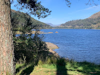
 Route: the road across the dam being closed, parking on the A591 near Bridge End farm and running along the road across the dam to find steps leading down to a footpath along the western side of Thirlmere, sometimes a wide gravel path, sometimes trippy by rock or root and slowing the pace to a walk. At Hause Point and at Dobgill Bridge, rejoining the road for 50m or so. At Stockhow Bridge, joining the road round the bottom of the lake to cross the A591 and here finding a signed narrow path (not marked on the map) north to Wythburn church. At the car park heading uphill at a walk and turning left along the wide stony forestry track. South of the straining well, being forced to continue on the initially lower main track rather than join a more level contouring path closed because washed away, presumably, by the 2015 floods. After climbing again, descending to Swirls car park, crossing the road and descending close to the shore (though the lake mainly hidden by trees) and following a clear path, then joining a narrow permissive path through woodlands before rejoining the track and gaining a bit of altitude and arriving at a junction for Great How. Here walking up a stony track then narrow path to the summit, surrounded by trees impeding the view to the lake (but not to the Near Eastern Fells, see picture. Retracing the route to the last junction and continuing along the track east of Great How, taking a permissive path towards the dam road and then back to the car.
Conditions: blue skies and blazing sunshine though the air was cool in the shade
Pub: the King's Head, Thirlspot for Charles Wells Bombardier
